US 380 Environmental Impact Statement From Coit Road to FM 1827
CSJs: 0135-02-065, 0135-03-053, 0135-15-002
Why Is This Study Being Done?
TxDOT’s 2016-2020 Collin County Feasibility Study was the very first step in the development of this project. The purpose of a feasibility study is to determine whether a project should proceed for further study and development, and to develop potential alignments. Feasibility Studies are conducted when the project may involve a major fund investment, a transportation solution is unknown, a major environmental concern is present, or a consensus of the general public and property owners along a route has not been developed. A Feasibility Study is meant to provide a high-level view of a potential project. Although TxDOT recommended a single alignment at the conclusion of the Feasibility Study, there were some other alternatives that are also reasonable, and those alternatives require more detailed study during the environmental review (NEPA) phase of the project, including alternatives that were eliminated during the Feasibility Study. Because this phase of the project involves a more detailed evaluation and collection of new information, it is possible that data being gathered could change previously studied alignments or lead TxDOT to consider new alternatives.
A feasibility study covers the following areas:
- The purpose of, and need for, a project;
- Conformance with the Texas Transportation Plan;
- Description of the limits of the study area;
- Social (e.g., a demographic profile), economic, and environmental features;
- Level of community support;
- Cost effectiveness;
- Infrastructure safety issues;
- Preliminary Level of Service analysis;
- Comparison of different routes, or corridors, and design alternatives;
- Analysis of existing transportation systems in the study area; and
- Alignment recommendations.
During the Feasibility Study, TxDOT used preliminary and available data to identify the location of its Recommended Alignment. Feasibility Study data included initial traffic and travel demand analysis as well as information from existing environmental databases. Field investigations and detailed analyses were not conducted at this step, which is the normal procedure for feasibility studies.
TxDOT announced its Feasibility Study Recommended Alignment to identify a general location for a possible freeway so that it could be considered for future growth and development plans. Because of existing and new homes and businesses, an expanding McKinney National Airport, parks, utilities, landfills and other environmental resources in the project vicinity, the list of project constraints and areas TxDOT needs to avoid is growing and the available land for a future freeway is becoming more and more limited.
Now that the Feasibility Study is complete, the project is progressing to the development of a schematic design and environmental study. While the feasibility study was a high-level look at
the project, schematic design and environmental study allows us to view the project “on the ground.” TxDOT is required to adhere to the National Environmental Policy Act (NEPA) process which includes the development of an Environmental Impact Statement (EIS). Adhering to NEPA is required on any project that would receive any federal funding. During this phase of project development, the federal governmental requires TxDOT to gather additional and more specific data to more fully develop and evaluate all reasonable alternatives to determine if they should be moved forward for further study or be eliminated. TxDOT is required to complete more in-depth traffic and travel demand analysis, and to complete an environmental study which includes in-person field assessments and surveys in areas where landowners have agreed to allow access. The purpose of the assessments is to determine locations of resources such as wetlands, floodplains, and culturally sensitive areas.
During this EIS, TxDOT will develop the schematic design which means that the following tasks must be completed:
- Determine number of lanes;
- Develop ramp location and interchange configurations;
- Determining the amount of land (also called right-of way) needed to construct the project;
- Complete drainage design;
- Consider bicycle and pedestrian accommodations; and
- Calculate more detailed cost estimates.
Included in EIS development is a federally required evaluation of potential environmental impacts. This includes impacts to air quality, archeological resources, biological resources, community impacts, hazardous materials, historic resources, protected lands (parks), traffic noise, and water resources, among other considerations. This is the phase of project development where TxDOT will be able to determine if sounds walls are feasible and where they could be placed. TxDOT is also required to complete more public involvement and coordination with resources agencies, municipalities, and major utility providers.
A more complete list of what TxDOT will consider in the comparison of alternatives can be found in the Public Scoping Meeting materials. This detailed comparison will ultimately help TxDOT make the most informed decision about the final, Preferred Alternative at the end of the of the EIS process. After the EIS is complete, the final, Preferred Alternative will move forward to detailed design and then to construction.
Project Description
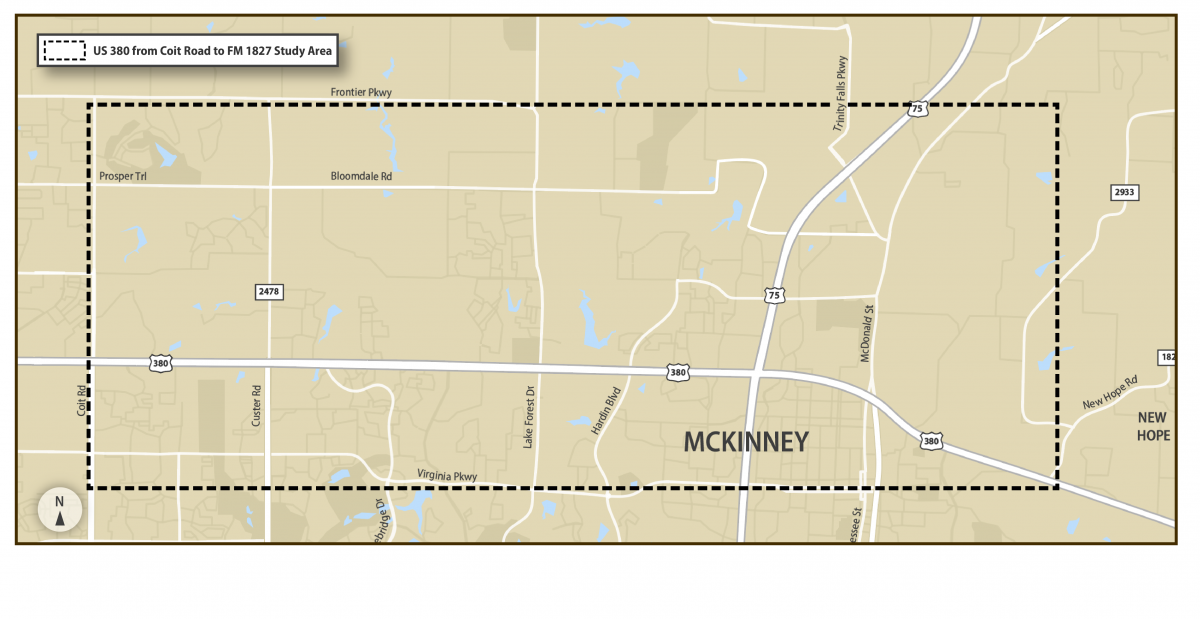
TxDOT is undertaking public involvement, schematic design, and an in-depth environmental study for the US 380 project from Coit Road to FM 1827 in Collin County. The project provides for development of a freeway facility to manage congestion and improve east-west mobility, connectivity, traffic operations, and safety through the project area shown below.
Population and employment growth in the area has caused increases in current and forecasted traffic volumes that exceed the capacity of the existing US 380 leading to increased congestion, reduced mobility, and higher crash rates compared to other similar roadways in the region.
Capacity and safety improvements in the existing US 380 corridor are constrained by residential, commercial, and industrial land uses; community resources; and environmental resources. As the population continues to grow, the options to improve the existing US 380 or build a new roadway become more limited and potential impacts to residential and commercial developments increase. TxDOT is working with local and regional partners to find ways to accommodate the growth and provide additional mobility options to keep up with travel demand.
TxDOT began this project in May 2020 and anticipated completion is late 2022. The project adheres to the National Environmental Policy Act (NEPA). The level of documentation identified is an Environmental Impact Statement (EIS) which will assess alternatives and outline impacts of the proposed project on the surrounding environment.
Alignments Under Consideration
The project will build on TxDOT’s US 380 Collin County Feasibility Study that was conducted from 2017-2020. Feasibility Study information can be viewed here. TxDOT will continue to consider its recommended feasibility study alignment, other viable alignments or changes to alignments, and a no-build alternative.
For an EIS, the study must include an assessment of all alternatives considered, and it is possible that the best alternative identified during that evaluation could differ from the recommended alignment from the feasibility study.
Notice of Intent
Agency and Public Scoping
An Agency Scoping Meeting was held for the proposed project on October 29, 2020. During this meeting, the proposed project’s scoping documents were presented to all cooperating and participating agencies for their review and comment. A Public Scoping Meeting was held for the proposed project from January 21, 2021 to February 5, 2021 at http://www.keepitmovingdallas.com/US380EISScopingMeeting. During this meeting, the proposed project’s scoping documents were presented to the public for review and comment.
The scoping documents can be found here:
Draft Purpose and Need
Range of Alternatives
Methodologies and Level of Detail for Analyzing Alternatives
Coordination Plan, including Schedule and Public Involvement Plan
Several comments/questions were repeatedly posed during the public scoping meeting. The following document provides those common comments and responses: Frequent Comments
Although the comment period for the scoping meeting has ended, questions and comments are always accepted. See contact information listed below.
Public Meeting Held March 22, 2022
A Public Meeting was held on March 22, 2022 to allow the public to learn more about the project and provide input on the proposed improvements.
The public meeting summary is available here:
March 2022 Public Meeting Summary Part 1 of 4
March 2022 Public Meeting Summary Part 2 of 4
March 2022 Public Meeting Summary Part 3 of 4
March 2022 Public Meeting Summary Part 4 of 4
Public Hearing Held February 16 through April 20, 2023
A public hearing was held in Spring 2023 to present the Draft Environmental Impact Statement (DEIS), announce the selection of the preferred alternative and receive public input. The public hearing materials can be viewed at https://www.keepitmovingdallas.com/US380EIS
The public hearing summary, including responses to comments, is available here:
Documentation of Public Hearing
Next Steps
The Final Environmental Impact Statement and Record of Decision is available for public review at www.keepitmovingdallas.com/us380eis.
Project Contact
For questions or comments, please contact:
Stephen Endres, P.E.
Stephen.Endres@txdot.gov
(214) 320-4469