- Home
- Interstate
Highways - US
Highways - State
Highways - FM
Roads - Other
Roads- Bus 114 From UP Railroad Underpass in Roanoke to DOT No. 795 342V
- Conflans Rd from SH 161 to Valley View Lane
- Elam Road From St. Augistine to Acres Dr
- Forest/Webb Chapel
- Gregory Road at Duck Creek
- Hampton/Inwood
- Kelly Boulevard From Rosemeade Pkwy to Michaelangelo Dr
- Lake Ridge Parkway
- Lake Ridge Parkway from Great Southwest Parkway to IH 20
- Loop 12 at White Rock Creek
- Loop 288 From US 380 tio IH 35E
- Loop 9 from I-35E to I-45
- Loop 9 from US 67 to I-20 (Southeast Corridor)
- Mountain Creek Parkway From Grady Niblo to SP 408
- Northwest Highway From Lawther to Goforth
- Spur 366 Extension (Woodall Rodgers)
- Spur 557 from Las Lomas Parkway to FM 148
- Spur 557 from FM 148 to IH 20
- Trinity Parkway
- West Lawther Drive
- Windhaven Parkway from 220 ft W of Gentle Way to Spring Creek Parkway
- Spur 399 Extension Environmental Impact Statement From US 75 to US 380
- Public
Hearings/Meetings - Contact
Us - Key Projects
(Dallas Planning) - CityMAP
Loop 9 from I-35E to I-45
CSJ: 2964-10-005
Loop 9 has been identified in transportation planning efforts for a number of years, but changes in demographics; traffic growth and forecasts; and the potential to connect to other major facilities have driven the need to re-evaluate the overall concept of the facility. Between 2006 and 2011, TxDOT developed schematic plans and evaluated potential natural, cultural, and socio-economic impacts for the Loop 9 Southeast project. The proposed project was evaluated as a 6-lane new location controlled access tollway with intermittent access roads between US 287 and I-20 within a 450- to 600-foot corridor depending on interchange location.
While the Loop 9 Southeast study was under review, TxDOT released a new vision for its corridor development process which resulted in the elimination of the Trans-Texas Corridor (TTC) concept. North Central Texas Council of Governments (NCTCOG) prepared the Regional Outer Loop Corridor Feasibility Study which did not recommend a continuous, circumferential outer loop because of expected low traffic volumes and a lack of statewide connections. The changes in TxDOT policy, funding constraints for transportation projects, and the current economic climate impacted the funding and advancement of transportation projects in the region which resulted in the suspension of the Loop 9 Southeast study until a determination on how the project should proceed was resolved (see Project History).
However, if you live or drive in southern Dallas County or northern Ellis County, you know that traveling through the area can still be a challenge. I-20, the closest east-west freeway, lies miles to the north. Arterial streets like Bear Creek Road and Belt Line Road are growing more congested as the area adds residential, commercial, and industrial development. More people living, shopping and working in the area means more vehicles on the roads. Heavy truck traffic from the Inland Port inter-modal freight facility near I-45 coupled with ongoing international freight movement may put even more pressure on the local transportation system.
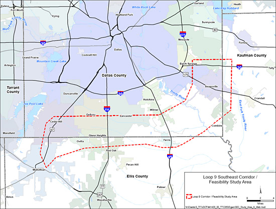
To address these transportation concerns, a new direction was identified for the Loop 9 Southeast project. TxDOT and NCTCOG, in cooperation with local government officials, worked together to prepare a Corridor/Feasibility Study for the Loop 9 Southeast study area from US 67 to I-20 (more information about the Corridor/Feasibility Study). Public Meetings were held in May and September 2013 (see Public Involvement for more information). The Corridor/Feasibility Study was completed and approved by TxDOT in March of 2014.
The Study recommends utilizing the currently available funding to begin engineering and environmental studies for the section of Loop 9 from I-35E to I-45 (Corridor B) first. This section is approximately 10 miles in length and is anticipated to cost $450 million. Subsequent sections would be advanced based on local needs and available funding.
TxDOT began development of the schematic and Environmental Assessment (EA) for the section of Loop 9 from I-35E to I-45 in April of 2014. Updates on this study and future public involvement activities will be provided as they become available.
Map of Corridor/Feasibility Study Area