- Home
- Interstate
Highways - US
Highways - State
Highways - FM
Roads - Other
Roads- Bus 114 From UP Railroad Underpass in Roanoke to DOT No. 795 342V
- Conflans Rd from SH 161 to Valley View Lane
- Elam Road From St. Augistine to Acres Dr
- Forest/Webb Chapel
- Gregory Road at Duck Creek
- Hampton/Inwood
- Kelly Boulevard From Rosemeade Pkwy to Michaelangelo Dr
- Lake Ridge Parkway
- Lake Ridge Parkway from Great Southwest Parkway to IH 20
- Loop 12 at White Rock Creek
- Loop 288 From US 380 tio IH 35E
- Loop 9 from I-35E to I-45
- Loop 9 from US 67 to I-20 (Southeast Corridor)
- Mountain Creek Parkway From Grady Niblo to SP 408
- Northwest Highway From Lawther to Goforth
- Spur 366 Extension (Woodall Rodgers)
- Spur 557 from Las Lomas Parkway to FM 148
- Spur 557 from FM 148 to IH 20
- Trinity Parkway
- West Lawther Drive
- Windhaven Parkway from 220 ft W of Gentle Way to Spring Creek Parkway
- Spur 399 Extension Environmental Impact Statement From US 75 to US 380
- Public
Hearings/Meetings - Contact
Us - Key Projects
(Dallas Planning) - CityMAP
Spur 399 Extension Environmental Impact Statement From US 75 to US 380
CSJ: 0364-04-051, 0047-05-058, 0047-10-002
Why Is This Study Being Done?
TxDOT’s 2016-2020 Collin County Feasibility Study was the very first step in the development of this project. The purpose of a feasibility study is to determine whether a project should proceed for further study and development, and to develop potential alignments. Feasibility Studies are conducted when the project may involve a major fund investment, a transportation solution is unknown, a major environmental concern is present, or a consensus of the general public and property owners along a route has not been developed. A Feasibility Study is meant to provide a high-level view of a potential project. Although TxDOT recommended a single alignment at the conclusion of the Feasibility Study, there were some other alternatives that are also reasonable, and those alternatives require more detailed study during the environmental review (NEPA) phase of the project, including alternatives that were eliminated during the Feasibility Study. Because this phase of the project involves a more detailed evaluation and collection of new information, it is possible that data being gathered could change previously studied alignments or lead TxDOT to consider new alternatives.
A feasibility study covers the following areas:
- The purpose of, and need for, a project;
- Conformance with the Texas Transportation Plan;
- Description of the limits of the study area;
- Social (e.g., a demographic profile), economic, and environmental features;
- Level of community support;
- Cost effectiveness;
- Infrastructure safety issues;
- Preliminary Level of Service analysis;
- Comparison of different routes, or corridors, and design alternatives;
- Analysis of existing transportation systems in the study area; and
- Alignment recommendations.
During the Feasibility Study, TxDOT used preliminary and available data to identify the location of its Recommended Alignment. Feasibility Study data included initial traffic and travel demand analysis as well as information from existing environmental databases. Field investigations and detailed analyses were not conducted at this step, which is the normal procedure for feasibility studies.
TxDOT announced its Feasibility Study Recommended Alignment to identify a general location for a possible freeway so that it could be considered for future growth and development plans. Because of existing and new homes and businesses, an expanding McKinney National Airport, parks, utilities, landfills and other environmental resources in the project vicinity, the list of project constraints and areas TxDOT needs to avoid is growing and the available land for a future freeway is becoming more and more limited.
Now that the Feasibility Study is complete, the project is progressing to the development of a schematic design and environmental study. While the feasibility study was a high-level look at
the project, schematic design and environmental study allows us to view the project “on the ground.” TxDOT is required to adhere to the National Environmental Policy Act (NEPA) process which includes the development of an Environmental Impact Statement (EIS). Adhering to NEPA is required on any project that would receive any federal funding. During this phase of project development, the federal governmental requires TxDOT to gather additional and more specific data to more fully develop and evaluate all reasonable alternatives to determine if they should be moved forward for further study or be eliminated. TxDOT is required to complete more in-depth traffic and travel demand analysis, and to complete an environmental study which includes in-person field assessments and surveys in areas where landowners have agreed to allow access. The purpose of the assessments is to determine locations of resources such as wetlands, floodplains, and culturally sensitive areas.
During this EIS, TxDOT will develop the schematic design which means that the following tasks must be completed:
- Determine number of lanes;
- Develop ramp location and interchange configurations;
- Determining the amount of land (also called right-of way) needed to construct the project;
- Complete drainage design;
- Consider bicycle and pedestrian accommodations; and
- Calculate more detailed cost estimates.
Included in EIS development is a federally required evaluation of potential environmental impacts. This includes impacts to air quality, archeological resources, biological resources, community impacts, hazardous materials, historic resources, protected lands (parks), traffic noise, and water resources, among other considerations. This is the phase of project development where TxDOT will be able to determine if sounds walls are feasible and where they could be placed. TxDOT is also required to complete more public involvement and coordination with resources agencies, municipalities, and major utility providers.
A more complete list of what TxDOT will consider in the comparison of alternatives can be found in the Public Scoping Meeting materials. This detailed comparison will ultimately help TxDOT make the most informed decision about the final, Preferred Alternative at the end of the of the EIS process. After the EIS is complete, the final, Preferred Alternative will move forward to detailed design and then to construction.
Project Description
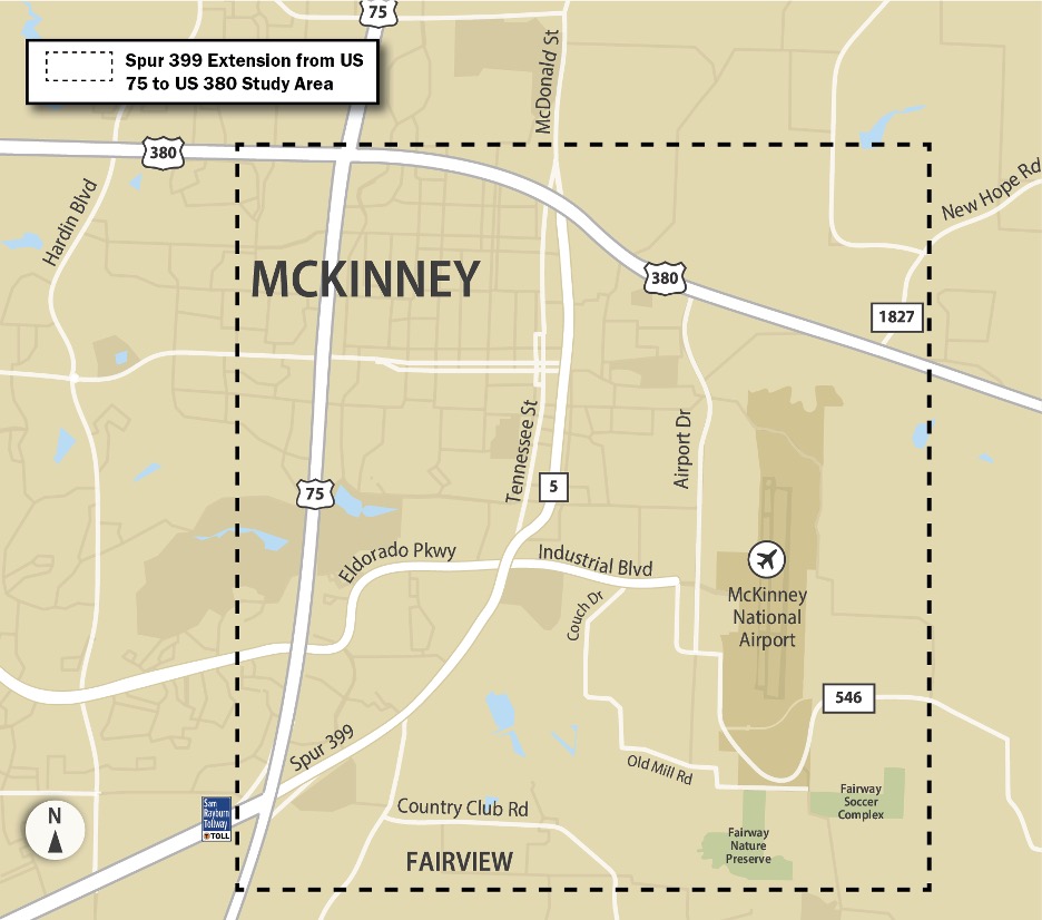
TxDOT is undertaking public involvement, schematic design, and an in-depth environmental study for the Spur 399 Extension project from US 75 to US 380. The project provides for development of a freeway facility to improve north-south mobility and connectivity of travelers from eastern Collin County to destinations south of McKinney, including the Dallas Metroplex. The existing Spur 399 is approximately 0.5 miles long and serves as a transition between and SH 121/Sam Rayburn Tollway (SRT) and SH 5, south of McKinney. The project area is shown below.
TxDOT began this project in May 2020 and anticipated completion is late 2022. The project adheres to the National Environmental Policy Act (NEPA). The level of documentation identified is an Environmental Impact Statement (EIS) which will assess alternatives and outline impacts of the proposed project on the surrounding environment.
Alignments Under Consideration
The project will build on TxDOT’s US 380 Collin County Feasibility Study that was conducted from 2017-2020. Feasibility Study information can be viewed here. TxDOT will continue to consider its recommended feasibility study alignment, other viable alignments or changes to alignments, and a no-build alternative.
For an EIS, the study must include an assessment of all alternatives considered, and it is possible that the best alternative identified during that evaluation could differ from the recommended alignment from the Feasibility Study.
Notice of Intent
Notice of Intent to Prepare an Environmental Impact Statement for Spur 399 Extension, Collin County
Agency and Public Scoping
An Agency Scoping Meeting was held for the proposed project on December 10, 2020. During this meeting, the proposed project’s scoping documents were presented to all cooperating and participating agencies for their review and comment. A Public Scoping Meeting was held for the proposed project from February 23, 2021 to March 10, 2021 at http://www.keepitmovingdallas.com/Spur399EISScopingMeeting . During this meeting, the proposed project’s scoping documents were presented to the public for review and comment.
The scoping documents can be found here:
Draft Purpose and Need
Range of Alternatives
Methodologies and Level of Detail for Analyzing Alternatives
Approved Coordination Plan
Several comments/questions were repeatedly posed during the public scoping meeting. The following document provides those common comments and responses: Frequent Comments
Public Meetings and Hearing
TxDOT held a public meeting on October 21, 2021. The public meeting materials can be viewed here:
The public meeting summary, including response to comments, is available here.
A DEIS has been prepared and a Public Hearing was held on November 10, 2022. The DEIS and Public Hearing materials can be viewed here.
The Public Hearing summary, including response to comments is available here.
Final Environmental Impact Statement (FEIS)/Record of Decision (ROD)
The Notice of Availability of the FEIS/ROD can be found here.
The FEIS/ROD is available for review here.
Next Steps
Now that the FEIS/ROD has been issued, TxDOT can begin acquiring right-of-way (ROW), complete the final design, and relocate utilities. This phase of project development is expected to take anywhere from two to four years.
Phased construction of the project would not begin until the project is fully funded. Constructed is anticipated to last three to four years after the final design phase is complete and all funding is identified.
The project has an anticipated Ready to Let date of 2026. Construction of a project begins after the letting process is complete. “Letting” is when TxDOT notifies the construction community that a project is ready to be bid on. The project is anticipated to be open to traffic between 2027 and 2037.
Project Contact
For questions or comments, please contact:
Stephen Endres, P.E.
Stephen.Endres@txdot.gov
(214) 320-4469