- Home
- Interstate
Highways - US
Highways- US 67 Widening Project from Belt Line Rd to I-20
- I-35E/US 67 Project
- US 75
- US 75 from Spring Creek Parkway to SH 121
- US 75 Express Lanes from I-635 to S of McDermott Drive
- US 75 Ridgeview Interchange
- US 77 from FM 66 to N of McMillan Street
- US80 at Proposed Forney Parkway
- US 80 & IH 635 Interchange Improvements
- US 287
- US 287 from SH 34 to IH 45
- US 287 Frontage Road Improvements Feasibility Study
- US 287 Widening from IH 45 to CR SE 2040
- US 287 at Walnut Grove Road
- US 377
- US 377 From Henrietta Creek Road to SH 114
- US 377 Widening from S of FM 1171 to Crawford Road
- US 380 Collin County Feasibility Study
- US 380 Denton County Feasibility Study
- US 380 Collin and Denton County
- US 380 from Loop 288 to West of CR 26
- US 380 from West of CR 26 to FM 2478
- US 380 from FM 1827 to CR 560 in Princeton area
- US 380 From FM 2478 to Bois D'Arc Road
- US 380 from Teel Parkway/Championship Drive to west of Lakewood Drive in Prosper/Frisco area
- SM Wright Project
- State
Highways - FM
Roads - Other
Roads - Public
Hearings/Meetings - Contact
Us - Key Projects
(Dallas Planning) - CityMAP
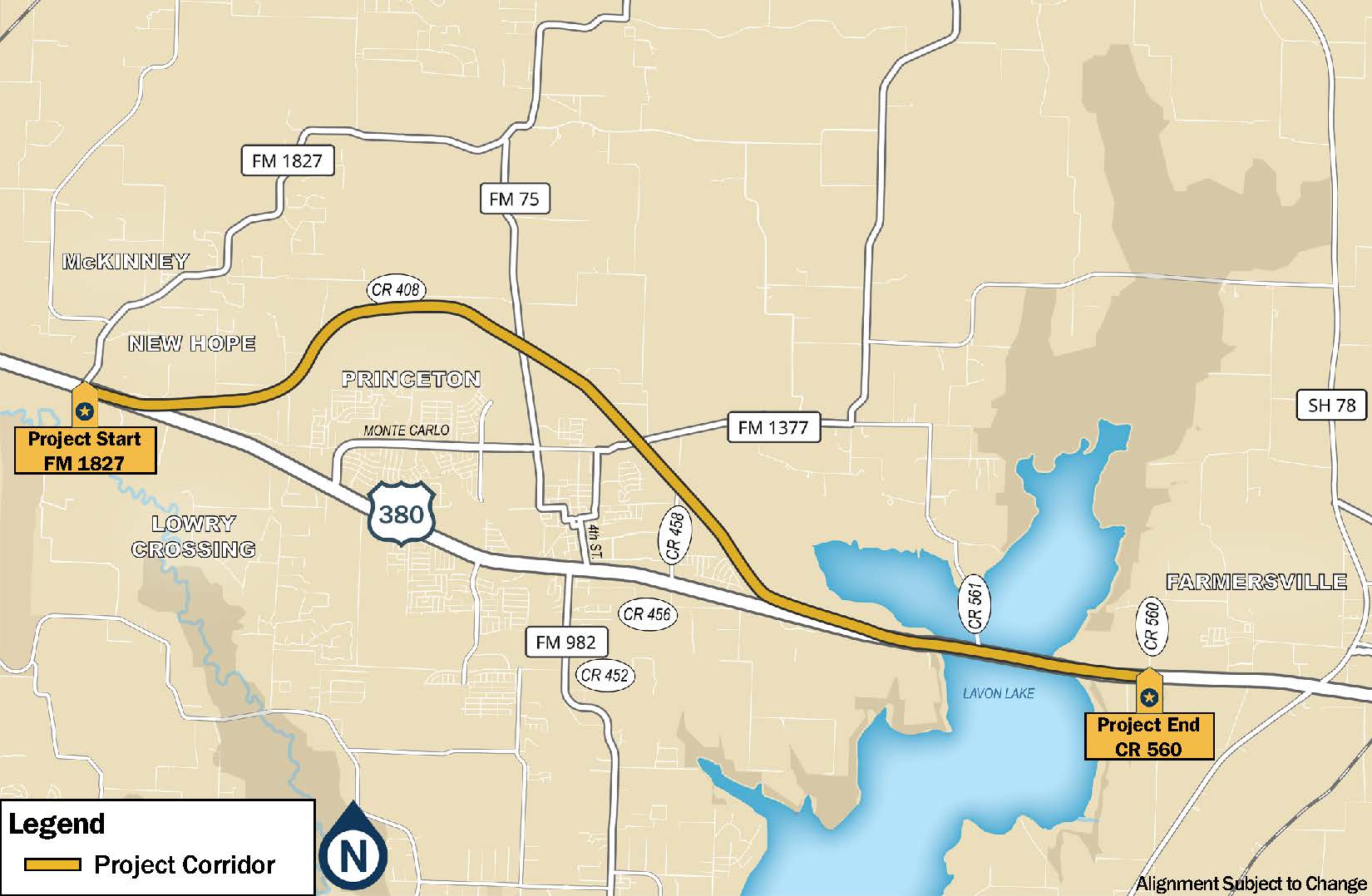
US 380 from FM 1827 to CR 560 in Princeton area
CSJ 0135-04-036, 0135-16-002, 0135-03-056
Project Description
TxDOT is undertaking schematic design, an in-depth environmental study, and public involvement for improvement of US 380 from FM 1827 to CR 560 in Collin County. The project length is approximately 11.8 miles. The project would construct a new location freeway beginning at FM 1827 and extending north around the city of Princeton, rejoining the existing US 380 alignment just west of Lavon Lake, from which point the existing US 380 would be reconstructed as a freeway to CR 560 east of the lake. The project area is shown below.
The purpose of the project is to reduce congestion, improve mobility and operations, and enhance safety by accommodating current and future traffic demands as a result of rapid development in Collin County. The proposed project incorporates current roadway design standards including improved pedestrian access through shared-use paths. The project is needed because the existing US 380 roadway does not meet current freeway design standards and cannot accommodate current and future traffic and population growth.
The project will build on TxDOT’s US 380 Collin County Feasibility Study that was conducted from 2017-2020. Feasibility Study information can be viewed here. Although the feasibility study alignment was the starting point for this current study, changes to the alignment may be necessary to provide the optimal schematic design and/or avoid environmental constraints. Please refer to the latest public meeting website (link below) for the most recent version of the proposed alignment.
The project adheres to the National Environmental Policy Act (NEPA). The level of documentation identified is an Environmental Assessment (EA), which will assess alternatives and identify impacts of the proposed project on the environment.
Why Is This Study Being Done?
TxDOT’s schematic and environmental study on US 380 from FM 1827 to CR 560 in the Princeton area is the next step of the department’s 2016-2020 Collin County Feasibility Study. The feasibility study was the very first step in the development of this project. The purpose of a feasibility study is to determine whether a project should proceed for further study and development, and to develop potential alignments. Feasibility Studies are conducted when the project may involve a major fund investment, a transportation solution is unknown, a major environmental concern is present, or a consensus of the general public and property owners along a route has not been developed. A Feasibility Study is meant to provide a high-level view of a potential project. Although TxDOT recommended a single alignment at the conclusion of the Feasibility Study, there were some other alternatives that are also reasonable, and those alternatives require more detailed study during the environmental review (NEPA) phase of the project, including alternatives that were eliminated during the Feasibility Study. Because this phase of the project involves a more detailed evaluation and collection of new information, it is possible that data being gathered could change previously studied alignments or lead TxDOT to consider new alternatives.
A feasibility study covers the following areas:
- The purpose of, and need for, a project;
- Conformance with the Texas Transportation Plan;
- Description of the limits of the study area;
- Social (e.g., a demographic profile), economic, and environmental features;
- Level of community support;
- Cost effectiveness;
- Infrastructure safety issues;
- Preliminary Level of Service analysis;
- Comparison of different routes, or corridors, and design alternatives;
- Analysis of existing transportation systems in the study area; and
- Alignment recommendations.
During the Feasibility Study, TxDOT used preliminary and available data to identify the location of its Recommended Alignment. Feasibility Study data included initial traffic and travel demand analysis as well as information from existing environmental databases. Field investigations and detailed analyses were not conducted at this step, which is the normal procedure for feasibility studies.
In May 2019 TxDOT announced its Feasibility Study Recommended Alignment to identify a general location for a possible freeway so that it could be considered for future growth and development plans. Because of existing and new homes and businesses, parks, utilities, landfills and other environmental resources in the project vicinity, the list of project constraints and areas TxDOT needs to avoid is growing and the available land for a future freeway is becoming more and more limited.
Now that the Feasibility Study is complete, the project is progressing to the development of a schematic design and environmental study. While the feasibility study was a high-level look at the project, schematic design and environmental study allows us to view the project “on the ground.” TxDOT is required to adhere to the National Environmental Policy Act (NEPA) process which includes the development of an Environmental Assessment (EA). Adhering to NEPA is required on any project that would receive any federal funding. During this phase of project development, the federal governmental requires TxDOT to gather additional and more specific data to more fully develop and evaluate all reasonable alternatives to determine if they should be moved forward for further study or be eliminated. TxDOT is required to complete more in-depth traffic and travel demand analysis, and to complete an environmental study which includes in-person field assessments and surveys in areas where landowners have agreed to allow access. The purpose of the assessments is to determine locations of resources such as wetlands, floodplains, and culturally sensitive areas.
During this process, TxDOT will develop the schematic design which means that the following tasks must be completed:
- Determine number of lanes;
- Develop ramp location and interchange configurations;
- Determining the amount of land (also called right-of way) needed to construct the project;
- Complete drainage design;
- Consider bicycle and pedestrian accommodations; and
- Calculate more detailed cost estimates.
Included in EA development is a federally required evaluation of potential environmental impacts. This includes impacts to air quality, archeological resources, biological resources, community impacts, hazardous materials, historic resources, protected lands (parks), traffic noise, and water resources, among other considerations. This is the phase of project development where TxDOT will be able to determine if noise walls are feasible and where they could be placed. TxDOT is also required to complete more public involvement and coordination with resources agencies, municipalities, and major utility providers.
This detailed comparison will ultimately help TxDOT make the most informed decision about the final, Preferred Alternative at the end of the of the EA process. After the EA is complete, the final, Preferred Alternative will move forward to detailed design and then to construction.
Project Schedule (updated November 2023)
- Fall 2020 – Schematic Design and Environmental Study began. Feasible alternatives evaluated.
- 2020-2022 Data collection and development of environmental footprint
- August 2022 Public Meeting held. Environmental Assessment begins.
- Summer 2022 – Spring 2024 – Develop schematic, conduct environmental studies. Concurrent US Army Corps of Engineers coordination.
- Spring-Summer 2024—Anticipated Public Hearing
- Fall-Winter 2024 – Anticipate environmental clearance
- Early 2025-Begin right of way (ROW) acquisition. ROW acquisition can begin even if construction funding is not identified.
- 2027 – Anticipated ready to let (dependent on identifying funding).
How to Get Involved
TxDOT held an in-person and virtual Public Meeting for this project on August 2, 2022. Public comments must be submitted by August 17, 2022 to be included in the meeting summary.
- Meeting website (includes maps and presentation)
- Meeting summary
Project Contact
For questions or comments, please contact the TxDOT Project Manager:
Stephen Endres, P.E.
Stephen.Endres@txdot.gov
(214) 320-4469