- Home
- Interstate
Highways - US
Highways- US 67 Widening Project from Belt Line Rd to I-20
- I-35E/US 67 Project
- US 75
- US 75 from Spring Creek Parkway to SH 121
- US 75 Express Lanes from I-635 to S of McDermott Drive
- US 75 Ridgeview Interchange
- US 77 from FM 66 to N of McMillan Street
- US80 at Proposed Forney Parkway
- US 80 & IH 635 Interchange Improvements
- US 287
- US 287 from SH 34 to IH 45
- US 287 Frontage Road Improvements Feasibility Study
- US 287 Widening from IH 45 to CR SE 2040
- US 287 at Walnut Grove Road
- US 377
- US 377 From Henrietta Creek Road to SH 114
- US 377 Widening from S of FM 1171 to Crawford Road
- US 380 Collin County Feasibility Study
- US 380 Denton County Feasibility Study
- US 380 Collin and Denton County
- US 380 from Loop 288 to West of CR 26
- US 380 from West of CR 26 to FM 2478
- US 380 from FM 1827 to CR 560 in Princeton area
- US 380 From FM 2478 to Bois D'Arc Road
- US 380 from Teel Parkway/Championship Drive to west of Lakewood Drive in Prosper/Frisco area
- SM Wright Project
- State
Highways - FM
Roads - Other
Roads - Public
Hearings/Meetings - Contact
Us - Key Projects
(Dallas Planning) - CityMAP
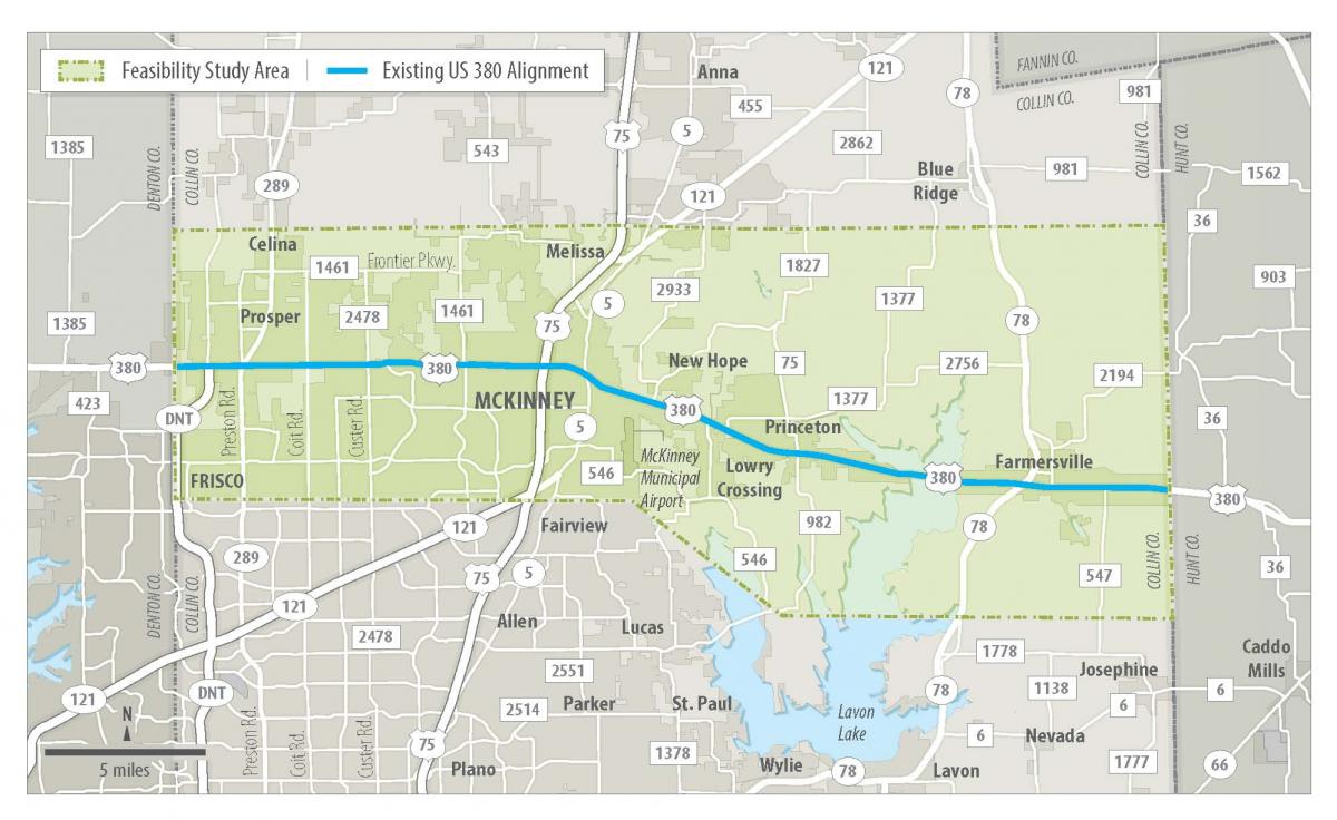
US 380 Collin County Feasibility Study
Project Map
What is the purpose of the study?
Analyze potential roadway alternatives, including the existing alignment and new alignments, for US 380 through Collin County from the Denton County line to the Hunt County line.
What is a feasibility study?
A feasibility study is one planning tool that TxDOT uses when a project is in the very early stages of development. It helps determine if the project should move on to more advanced phases of project development such as more in-depth environmental analysis, public involvement, schematic design and right-of-way mapping.
The reason this type of study is done is to identify high level or critical elements of engineering, impacts to stakeholders and the public, and the economic feasibility of potential new roadways or improvements to existing roadways.
Feasibility studies are not intended to result in detailed design, environmental analysis, or cost estimates.
What will be evaluated in this feasibility study?
The study team will consider projected regional traffic, existing and planned developments, stakeholder input and the impact on the economy and environment.
What are expected project milestones?
Summer 2017 – Study begins
Spring 2018 and Fall 2018 – Public open house meetings will be held to discuss the project and gather feedback from the public
Spring 2019 – Project implementation plan finalized that would include a recommended alignment(s)
*Please note that the project schedule is subject to change.
Why is the study being conducted?
The County is growing…
The population of Collin County is projected to grow from just under 800,000 people (2010 Census) to over 3.8 million people in 2050, according to the Texas Demographic Center.*
*Assume the 2000-2010 Migration scenario for 2014 Texas Population Projections
More and more land in the County is being preserved for developments.
The study team is working with Collin County and cities in the study area to identify land which has been purchased and right of way that is preserved for existing or future planned residential or commercial development. As the County’s population grows, the options to build a new roadway or expand the existing US 380 become more limited and potential impacts to residential and commercial developments increase. The feasibility study will identify a roadway alignment or alignments to serve as a blueprint for City staff to begin preserving land now.
When will construction begin?
There are many steps that must be completed after this project before construction could begin such as a more in-depth environmental analysis and public involvement, schematic design, right-of-way mapping and detailed roadway design.
US 380 FAQs
FAQs Following May 2019 Public Meetings
US 380 Collin County Feasibility Study Final Report
US 380 Collin County Feasibility Study Final Report
US 380 Illustrative Rendering
Draft Illustrative Renderings at Stonebridge and Tucker Hill
US 380 May 2019 Public Meeting Documentation
US 380 May 2019 Public Meeting Documentation
US 380 Presentation Slides
US 380 Presentation Boards
TxDOT Recommended Alignment Route Map
Sheet 1 – Denton County Line to Custer Rd.
Sheet 2 –Custer Rd. to McDonald St./Highway 5
Sheet 3 –McDonald St./Highway 5 to Monte Carlo Blvd.
Sheet 4 –Spur 399 Extension/McKinney National Airport Area
Sheet 5 – Monte Carlo Blvd. to Lake Lavon
Sheet 6 –Lake Lavon to Hunt County Line
US 380 How to Provide Input
Electronic Survey/Comment Card
https://www.surveymonkey.com/r/US380FeasibilityStudy
Comment period closes on Friday, May 24, 2019.
US 380 MAPO (Prosper) Presentation Boards
US 380 MAPO (Prosper) Alignment
US 380 MAPO (Prosper) Comment Form
US 380 Prosper MAPO Meeting
US 380 NE McKinney MAPO Meeting
Public Meeting - Thursday, October 4, 2018 - Frisco
Public Meeting - Tuesday, October 9, 2018 - McKinney
Public Meeting - Thursday, October 11, 2018 - Princeton
Documentation of Public Meetings
US 380 Presentation Slides
US 380 Presentation Boards
US 380 Environmental Constraints Map
Revised Green Alignment Route Maps w/ Options A and B
- Sheet 1 – Denton County Line to Custer Rd.
- Sheet 2 –Custer Rd. to McDonald St./Highway 5
- Sheet 3 –McDonald St./Highway 5 to Monte Carlo Blvd.
- Sheet 4 –Spur 399 Extension/McKinney National Airport Area
- Sheet 5 – Monte Carlo Blvd. to Lake Lavon
- Sheet 6 –Lake Lavon to Hunt County Line
Revised Red Alignment Route Maps w/ Options A and B
- Sheet 1 – Denton County Line to Custer Rd.
- Sheet 2 –Custer Rd. to McDonald St./Highway 5
- Sheet 3 –McDonald St./Highway 5 to Longneck Rd./FM 75
- Sheet 4 –Spur 399 Extension/McKinney National Airport Area
- Sheet 5 – Longneck Rd./FM 75 to Lake Lavon
- Sheet 6 –Lake Lavon to Hunt County Line
US 380 How to Provide Input
The public meeting comment period has ended.
Public Meeting - Thursday, April 26, 2018 - McKinney
Public Meeting - Tuesday, May 1, 2018 - Princeton
Public Meeting - Thursday, May 3, 2018 - Prosper
Documentation of Public Meetings
US 380 Presentation Slides
US 380 Presentation Boards
US 380 Constraints Map
US 380 Travel Time Estimator Tool
Green Alignment Route Maps
- Sheet 1 - Denton County Line to Custer Rd.
- Sheet 2 - Custer Rd. to McDonald St./Highway 5
- Sheet 3 - McDonald St./Highway 5 to Monte Carlo Blvd.
- Sheet 4 - Spur 399 Extension/McKinney National Airport Area
- Sheet 5 - Monte Carlo Blvd. to Lake Lavon
- Sheet 6 - Lake Lavon to Hunt County Line
Pink Alignment Route Maps
- Sheet 1 - Denton County Line to Custer Rd.
- Sheet 2 - Custer Rd. to McDonald St./Highway 5
- Sheet 3 - McDonald St./Highway 5 to Monte Carlo Blvd.
- Sheet 4 - Spur 399 Extension/McKinney National Airport Area
- Sheet 5 - Monte Carlo Blvd. to Lake Lavon
- Sheet 6 - Lake Lavon to Hunt County Line
Blue Alignment Route Maps
- Sheet 1 - Denton County Line to Custer Rd.
- Sheet 2 - Custer Rd. to McDonald St./Highway 5
- Sheet 3 - McDonald St./Highway 5 to Monte Carlo Blvd.
- Sheet 4 - Spur 399 Extension/McKinney National Airport Area
- Sheet 5 - Monte Carlo Blvd. to Lake Lavon
- Sheet 6 - Lake Lavon to Hunt County Line
Yellow Alignment Route Maps
- Sheet 1 - Denton County Line to Custer Rd.
- Sheet 2 - Custer Rd. to McDonald St./Highway 5
- Sheet 3 - McDonald St./Highway 5 to Monte Carlo Blvd.
- Sheet 4 - Spur 399 Extension/McKinney National Airport Area
- Sheet 5 - Monte Carlo Blvd. to Lake Lavon
- Sheet 6 - Lake Lavon to Hunt County Line
Red Alignment Route Maps
- Sheet 1 - Denton County Line to Custer Rd.
- Sheet 2 - Custer Rd. to McDonald St./Highway 5
- Sheet 3 - McDonald St./Highway 5 to Monte Carlo Blvd.
- Sheet 4 - Spur 399 Extension/McKinney National Airport Area
- Sheet 5 - Monte Carlo Blvd. to Lake Lavon
- Sheet 6 - Lake Lavon to Hunt County Line
Feasibility Study
AECOM US 380 Feasibility Study Report
US 380 MAPO Presentation Boards
US 380 MAPO Alignment
US 380 MAPO Comment Form
US 380 How to Provide Input
The public meeting comment period has ended.
For questions or comments, please contact:
Stephen Endres, P.E.
(214) 320-4469