- Home
- Interstate
Highways - US
Highways - State
Highways- SH 5 from SH 121 to CR 375
- SH 5 From Stacy Rd to Exchange Pkwy
- SH 31 from 3.2 miles W of FM 2555 to 3.7 miles E of IH 45
- SH 31 Relief Route from SH 31 W of Corsicana to SH 31 E of Corsicana
- SH 34 from 1.375 Miles Southwest of FM 1388 to SH 243
- SH 34 from Airport Road to High Street
- SH 34 Feasibility Study
- SH 66 from SH 205 to FM 1777
- SH 78 From SH 205 to FM 6
- SH 78 at Gaston Ave
- SH 78 From Spring Creek Parkway to SH 205
- SH 114 at US 377
- SH 114 and SH 170 Freeway Widening
- SH 114 at FM 156
- SH 114 From E of International Parkway to SH 183
- SH 114 From West of County Line Road to W of FM 156
- SH 114 from Wise County Line to IH 35W
- SH 121 Improvement Project from FM 455 to CR 635
- SH 121
- SH 160 From CR 534 to SH 121
- SH 161 From IH 20 to SH 183
- SH 161 from South of Conflans Road to North of SH 114
- SH 183
- SH 183 / Loop 12 / SH 114 / Spur 482 Interchange
- SH 190 - The East Branch
- SH 190 - The East Branch from I-30 to I-20
- SH 205
- SH 205 from US 80 to SH 78
- SH 276 from SH 205 to FM 549
- SH 289 at Plano Parkway
- SH 289 @ US 380 Interchange
- SH 289 From Grayson CR 60 to US 380
- SH 289 From US 380 to FM 3537
- SH 352 from N of Kearney Street to US 80 EB FR
- SH 360 from E. Sublett Road/W. Camp Wisdom Road to US 287
- SM Wright Project
- Loop 12 and SH 183 Interchange and SH 183/Spur 482 and SH 114 Irving Interchange project
- FM
Roads - Other
Roads - Public
Hearings/Meetings - Contact
Us - Key Projects
(Dallas Planning) - CityMAP
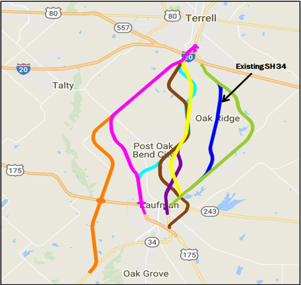
SH 34 Feasibility Study
From FM 2578 in Terrell to SH 243 in Kaufman
CSJ: 0173-04-056
Project Map
SH 34 Study Goals
The goal of the study is to evaluate existing SH 34 and other options identified in the surrounding area of SH 34 in order to better serve the community. Along with partners, we are evaluating:
- Improvements in safety and mobility
- Reduction in traffic congestion
- Population growth
- Social and community impacts
- Environmental and socio-economical impacts
- Savings in maintenance and construction costs
What is a Feasibility Study?
- A feasibility study is when a project is in the very early stages of development.
- The study helps determine if the project should move forward to more in-depth environmental analysis, public involvement, schematic design and right-of-way mapping.
- The project team, in coordination with the working group comprised of city and county officials, and stakeholders, would develop project goals and objectives, assess environmental and engineering constraints, and identify preliminary route options.
- With input from the public and community, and additional technical analysis, the project team would refine and recommend route options for further study.
- These route options would be the starting point for any future phases of project development, including an environmental study, should the project advance.
SH 34 Presentation Slides
SH 34 Presentation Boards
SH 34 Traffic Boards
SH 34 Constraints Map
- CSJ_017304056_BOARD_Environmental Constraints Human
- CSJ_017304056_BOARD_Environmental Constraints Natural
Blue Alignment Route Maps
- Sheet 1 – CSJ_017304056_ROLL_Blue Alignment_1
- Sheet 2 – CSJ_017304056_ROLL_Blue Alignment_2
- Sheet 3 – CSJ_017304056_ROLL_Blue Alignment_3
Brown Alignment Route Maps
- Sheet 1 – CSJ_017304056_ROLL_Brown Alignment_1
- Sheet 2 – CSJ_017304056_ROLL_Brown Alignment_2
- Sheet 3 – CSJ_017304056_ROLL_Brown Alignment_3
- Sheet 4 – CSJ_017304056_ROLL_Brown Alignment_4
Green Alignment Route Maps
- Sheet 1 – CSJ_017304056_ROLL_Green Alignment_1
- Sheet 2 – CSJ_017304056_ROLL_Green Alignment_2
- Sheet 3 – CSJ_017304056_ROLL_Green Alignment_3
- Sheet 4 – CSJ_017304056_ROLL_Green Alignment_4
Light Blue Alignment Route Maps
- Sheet 1 – CSJ_017304056_ROLL_Light Blue Alignment_1
- Sheet 2 – CSJ_017304056_ROLL_ Light Blue Alignment_2
- Sheet 3 – CSJ_017304056_ROLL_ Light Blue Alignment_3
- Sheet 4 – CSJ_017304056_ROLL_ Light Blue Alignment_4
Orange Alignment Route Maps
- Sheet 1 – CSJ_017304056_ROLL_Orange Alignment_1
- Sheet 2 – CSJ_017304056_ROLL_Orange Alignment_2
- Sheet 3 – CSJ_017304056_ROLL_Orange Alignment_3
- Sheet 4 – CSJ_017304056_ROLL_Orange Alignment_4
- Sheet 5 – CSJ_017304056_ROLL_Orange Alignment_5
Pink Alignment Route Maps
- Sheet 1 – CSJ_017304056_ROLL_Pink Alignment_1
- Sheet 2 – CSJ_017304056_ROLL_Pink Alignment_2
- Sheet 3 – CSJ_017304056_ROLL_Pink Alignment_3
- Sheet 4 – CSJ_017304056_ROLL_Pink Alignment_4
Purple Alignment Route Maps
- Sheet 1 – CSJ_017304056_ROLL_Purple Alignment_1
- Sheet 2 – CSJ_017304056_ROLL_Purple Alignment_2
- Sheet 3 – CSJ_017304056_ROLL_Purple Alignment_3
Yellow Alignment Route Maps